PRojects
La Punilla, San Juan, Argentina
Overview and Location
Ronin Resources has announced its application for the La Punilla gold-silver project in San Juan, Argentina, covering 23,637 hectares. This strategic move is part of Ronin’s efforts to enhance its exploration activities and capitalize on the mineral-rich San Juan Province, known for its significant copper-gold-silver-molybdenum deposits. We are focused on acquiring high-quality gold projects with strong geological fundamentals and clear potential to deliver shareholder value. Our strategy emphasizes disciplined, value-accretive acquisitions with a long-term outlook.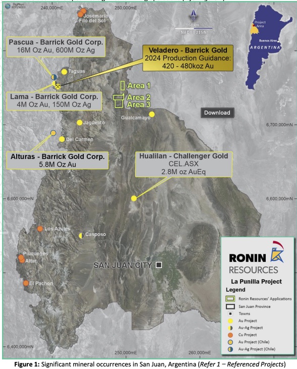
Initial Sampling Confirms Gold-Silver-Copper Mineralisation at La Punilla, San Juan.
Ronin Resources has received assay results from initial surface sampling at its 100%-owned La Punilla Project, located in San Juan Province, Argentina. Results confirm epithermal quartz-sulphide veining hosted in Devonian sandstones and support the presence of a near-surface, low-sulphidation epithermal system.

Highlights include:
Up to 0.27 g/t Au, 5.6 g/t Ag, and 0.12% Cu returned from rock-chip sampling A second sample returned 0.11 g/t Au and 0.02% Cu, consistent with peripheral halo mineralisation Mineralisation is located within a 500 m × 250 m hematite-limonite alteration zone (colour anomaly) Geochemistry and alteration are consistent with epithermal systems in the Precordillera belt, including the regional Gualcamayo gold-silver mine Sampling targeted accessible outcrop areas on the northeastern margin of the alteration zone, where steep terrain restricted entry to the central zone. Pathfinder elements including arsenic and bismuth accompany the gold-copper anomalism and reinforce the interpretation of an epithermal system. Further along strike, quartz veins become more massive and barren with reduced sulphides and iron oxides. Sediment sampling in adjacent concessions returned no significant results; however, access constraints left multiple areas untested.Follow-up Exploration
Ronin will advance exploration with:- Extended mapping and sampling across the full colour anomaly
- Integrated geological–geophysical modelling to define priority trenching/drilling targets
The Vetas Project
Overview and location
The Vetas Project consists of one mining title and one mining concession application. The project is located 50 km north of the town of Tibu, Norte de Santander in northeast Colombia, 5 km south of La Gabarra village and approximately 20 km from the Venezuelan border.
The project area lies in the North Catatumbo area, in the eastern foothills of the Eastern Andean Cordillera within the Perijá Mountain Range, comprising hills and valleys transected by the Catatumbo, Río de Oro and Eusebio rivers.
The elevation in the project area ranges between 50 – 350 m above sea level. The city of Cucuta is approximately 170 km to the south of the deposit and the Colombian ports near Santa Marta on the Caribbean coast are about 600 km to the northwest of the project area.
The Vetas Project can be accessed by a road connecting the town of Tibú and La Gabarra village (50 km); from Tibu to the west a minor road (Convencion-El Tarra) of approximately 200 km winds through the Eastern Cordillera to the Magdalena River Valley where a main national road and the rail line (La Dorada – Chiriguana) connects to the Caribbean ports.